Canadian coverage is not the best on Caltopo. Missing trails, lack of local knowledge, some things are not tailored for our country. I tried to find the best maps I could to help me in my local explorations. Here is what I found.
Base map setting
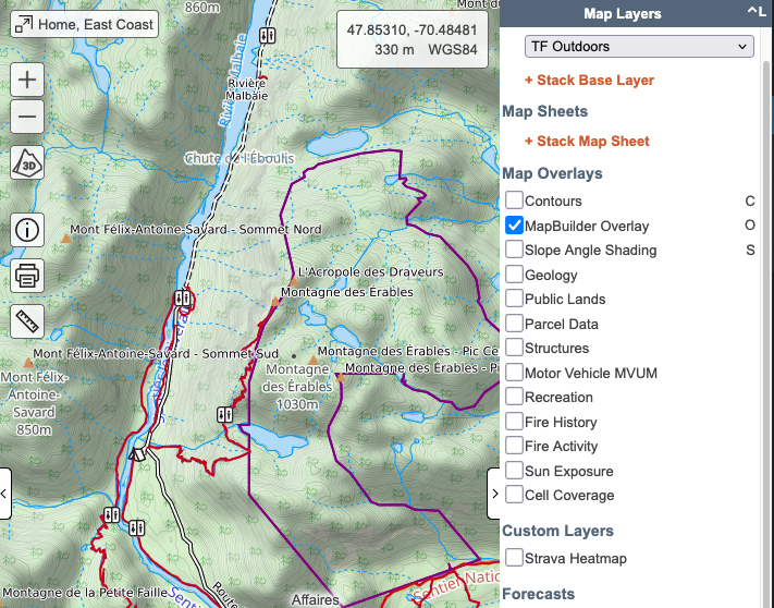
I use « TF Outdoors » + MapBuilder Overlay as my base visualisation for all my maps. It allows me to have a good level of trail details with the benefits of a proper topo map in the background. Note that TF Outdoors reflects pretty quickly changes made in OpenStreetMap, so it’s a definitive plus.
Alternatively, switching TF Outdoors to a satellite view gives great contrast with the MapBuilder Overlay, and allows to make tracks over forestry roads very easily. You can still see legal limits for parcs, etc. which is great.
Custom Layers
Canada Base Map Transportation:
Very precise base map, with a huge amount of detail for small and old trails.
https://maps-cartes.services.geo.ca:443/server2_serveur2/services/BaseMaps/CBMT3978/MapServer/WmsServer?SERVICE=WMS&VERSION=1.1.1&REQUEST=GetMap&STYLES=&BBOX={left},{bottom},{right},{top}&WIDTH={tilesize}&HEIGHT={tilesize}&BGCOLOR=0xCCCCCC&FORMAT=image/png&EXCEPTIONS=application/vnd.ogc.se_inimage&SRS=EPSG:4326&LAYERS=0,1Thunderforest Landscape
Beautifull nature background. Not too much data, but makes for a great base map.
https://tile.thunderforest.com/landscape/{Z}/{X}/{Y}.png?apikey=XXXXXXStrava Heatmap
Usefull to find other people ski lines and running spots 🙂
https://heatmap-external-b.strava.com/tiles/all/bluered/{Z}/{X}/{Y}.pngCanada Toporama
Canadian atlas. A very good topo map, with a very good level of detail
https://cartes.geogratis.gc.ca/wms/toporama_fr?SERVICE=WMS&VERSION=1.1.1&REQUEST=GetMap&STYLES=&BBOX={left},{bottom},{right},{top}&WIDTH={tilesize}&HEIGHT={tilesize}&BGCOLOR=0xCCCCCC&FORMAT=image/png; mode=24bit&EXCEPTIONS=application/vnd.ogc.se_inimage&SRS=EPSG:3857&LAYERS=SCW-ToporamaQuébec 20k topo map
Scanned topo map with some exclusive data.
https://servicesmatriciels.mern.gouv.qc.ca/erdas-iws/ogc/wms/Cartes_Images?SERVICE=WMS&VERSION=1.1.1&REQUEST=GetMap&STYLES=&BBOX={left},{bottom},{right},{top}&WIDTH={tilesize}&HEIGHT={tilesize}&BGCOLOR=0xCCCCCC&FORMAT=image/png&EXCEPTIONS=application/vnd.ogc.se_xml&SRS=EPSG:3857&LAYERS=BDTQ-20KMap Wrapper
Map Wrapper is a very good tool that allows you to build custom maps, wrap images and PDFs to use them as custom map backgrounds. I use it to import old maps. Nothing like navigating on a 1882 hand drawn map!